Route Summary
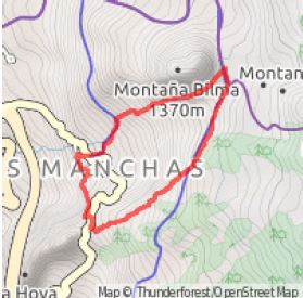
 The walk rises out of Las Manchas on old paths, soon passing a little Ermita at a prominent vantage point, before climbing up, alongside, and across the Chinyero lava fields that almost devastated the area in 1909. Great views are a feature of this walk on every step of the way.
Duration: 3 hours
Route Overview
Duration: 3 hours.
Transport/Parking: Very infrequent Titsa 461/462 from Santiago del Teide. Parking on street in Las Manchas  close to church.
Length: 6.100 km / 3.81 mi
Height Gain: 332 meter
Height Loss: 332 meter
Max Height: 1251 meter
Min Height: 967 meter
Surface: Mostly rough stony paths and rough roads.
Child Friendly: Yes, but only only if children are used to strenuous uphill hikes on rough surfaces..
Difficulty: Moderate.
Dog Friendly: Yes.
Refreshments: Santiago del Teide or Tamaimo.
Description
 This relatively short walk involves a moderately strenuous overall ascent to achieve marvellous grandstand views of the whole Santiago del Teide area. Starting at the church in the little village of Las Manchas we climb up the north-west flank of Montaña La Hoya on an old path to the charming little white-walled Ermita de Santo Angel de la Guardia which overlooks the valley below. Looking upward over the pine forests we can see the peak of El Teide. From here we ascend up the edge of the area of lava flow from Chinyero in 1909 that almost overwhelmed the municipality of Santiago del Teide. The route then traverses the lava fields, looking down to little Las Manchas, far below you now. Skirting the base of the prominent volcanic cone of Montaña Bilma the path then slowly descends back to the starting point, with great views down to the coast at Puerto Santiago, passing a shrine dedicated to the aversion (by prayer, reputedly) of the tragedy that almost befell Las Manchas in 1909, and its neighbouring towns and villages. The final section before the village, between dry stone walls, passes through an area of almond trees.
Links:
Photos from walk
Download Route Guide (PDF with illustrated Waypoints)
Download GPX file (GPS Exchange Format)
Access Walk on Viewranger
Access Walk on Wikiloc

