
Route Summary
 From the old-world charm of Arico Nuevo through a landscape of golden stone, rural terraces, and wild barrancos. This walk has so much going for it!
Duration: 2.5 to 3 hours.
Route Overview
Duration: About 2.5 to 3 hours.
Transport/Parking: Titsa 416 from Los Cristianos to Granadilla, then Titsa 36 to Guimar. Parking in the plaza or nearby.
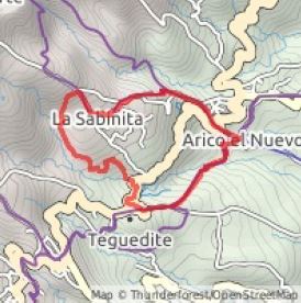 Length: 6.410 km / 4.01 mi
Height gain: 319 meter
Height loss: 319 meter
Max Height: 589 meter
Min Height: 339 meter
Surface: Average
Child Friendly: Yes
Difficulty: Easy
Dog Friendly: Yes
Refreshments: Drinks and local meals/snacks in Tasca La Zurrapa in plaza at Arico Nuevo.
Description
 Strolling around Arico Nuevo and appreciating its old-world charm and centuries-old architecture, before or after your walk, is a must! The walk itself starts in the plaza and heads out on the old rural trail to Villa de Arico, at first crossing the Barranco Polegre, surrounded by wildflowers and the golden-stone agricultural terraces at every turn on the old camino. Arriving at the El Viso area, you break away from the Villa de Arico route and head up to the main road for a short section before taking an, at first, indistinct and disused path, largely following the impressive Barranco Polegre as you skirt around the edges of the village of La Sabinita. Reaching the upper outskirts of the village you walk down to the plaza and then follow the trail down to the village of La Degollada. There are impressive mountain and pine forest views above you, particularly in the direction of Barranco de Tamadaya. From La Degollada you take an old cobbled road down to the entrance to Arico Nuevo where there is a delightful stroll down to the plaza past some seriously impressive 18th Century buildings and their “built to last” wooden doors! A friendly refreshment awaits in the Tasca La Zurrapa.
Links:
Photos from walk (note some photos from a previous visit to Arico Nuevo)
Download GPX file (GPS Exchange Format)
Download Route Guide PDF (with illustrated Waypoints)
Access Walk on Viewranger
Access Walk on Wikiloc
